Plotting My Ancestor’s Land on a Current Map

As I have mentioned before, much of my research is in Maryland.  In Maryland, all land records are on-line.  That makes finding specific locations for my ancestors’ homes and businesses a little easier since it can be done from home.  There are a lot of tools out there, free and paid, to help plot the information found in the deeds available on-line.  But for my 5th great-grandfather Joshua Whitaker, someone else did much of the work, I just reap the rewards of his hard work!

If you have an early landowner in Baltimore or Harford County, Maryland you may want to check this out as well.

Below is the final result of my search, then I will talk about how I got there:

Map of Joshua Whitaker’s property generated in Google Earth

Step One – Finding THE Land Records

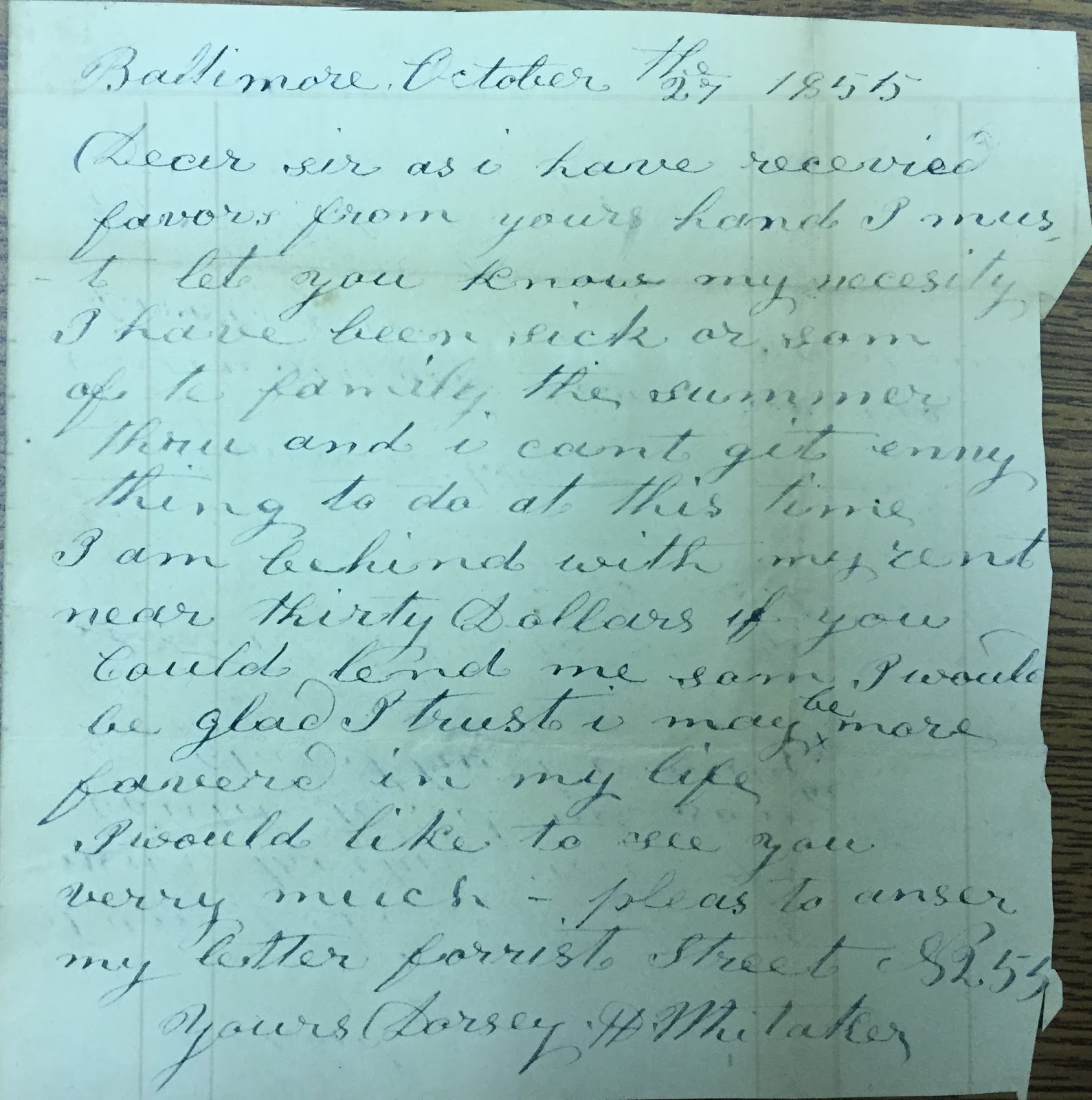
My original search involved searching https://mdlandrec.net/main/ for land records for Joshua Whitaker.  Joshua was born in 1761, probably in Baltimore County, Maryland since Harford County was not formed until 1774.  Joshua married Ruth Howard in 1781 at about aged 20, so I assumed I should start searching for him in the Harford County land records around 1780 or so.  I found several deeds for Joshua Whitaker and I attempted to plot them out.  Earlier land records are harder to plot (in my opinion) because the property line references are defined very differently than today.  Many times the property lines are defined as a tree line or the edge of a stream, not necessarily as bearings and distances like they are now.  So my progress was S-L-O-W.

Along with the MDLANDREC site, the Maryland State Archives has also made plats available on-line.  So I also headed to plats.net and searched “Whitaker” (in the Advanced Search) to see what came up.  Two of the records caught my eye:

  1. A Patented Certificate in 1819 for “Whitacres Invitation”
  2. An Equity Record from 1825 for “Property of the late Whitaker, Joshua”

My Joshua died in 1818 so the 1819 certificate was a head scratcher.  But it was possible that the Equity Record could be for him.

Time to look at the actual documents.  The document contained 9 pages but I will highlight 2 of them here.

Looking at the 1st image of the Patented Certificate it was possible that this was my Joshua. It was surveyed in 1815 and passed in 1816.

Source: Harford County Circuit Court (Certificates, Patented, HA) Patented Certificate 878, MSA_S1199_892, page 1 of 9.

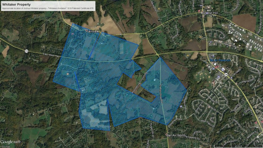
And page 3 had a plot of the land:

Source: Harford County Circuit Court (Certificates, Patented, HA) Patented Certificate 878, MSA_S1199_892, page 3 of 9.

Then I looked at the Equity Record.  I know from Joshua’s will that his property was to be divided between his wife and several of his children.

Source: Harford County Circuit Court (Plats on Microfilm, HA Index) Equity Record ALJ 18, p. 279. MSA_S1540_1495.

Cool!  The basic outline of the 2 records match.  And, referring back to the will, this is my Joshua.

So now I have a plot of the land that Joshua Whitaker owned but it will take a lot of work to put Joshua’s land on a current map to see exactly where this land was.

Step Two – Locate on today’s map

For a while I tried using the land records going forward in time to plot Joshua’s land in today’s landscape.  It was frustrating and I was mostly unsuccessful.

And then I stumbled upon a simple looking ABSOLUTELY WONDERFUL website.  One of the pieces of software I use to plot land is called DeedMapper from Direct Line Software.  Besides the software, their site includes a Research Directory (so you can see others researching land records in an area) and a Deed Data Pool (customer contributed deed files).  In looking at the Deed Data Pool I found a Baltimore County and a Harford County file contributed by Mike Pierce.  Clicking on the Harford County file led me to a page containing the Deed Mapper file for Harford County.  This was great because it allowed me to download the file and open it in the DeedMapper program with a background map.

But the really great part was when I went back to the base web address http://map-maker.org/ and saw everything Mike Pierce’s “The Happy Map-Maker’s Website”.

This site includes searching aids for Baltimore County and City, his aforementioned DeedMapper files, information on leases and land grants in Baltimore and Harford Counties and an animated progression of land grants in said counties.  GREAT resources.

But the pièce de résistance is a Google Earth version of the Baltimore and Harford County leases and land grants. AAAAHHHHH!  Since Google Earth is one of my most favorite tools, this is awesome!

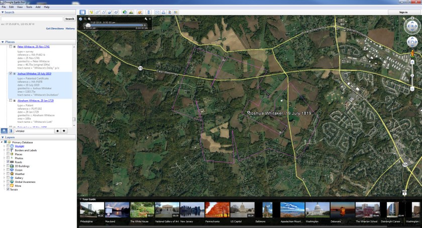
So I opened the Harford County patents, downloaded the file and opened the KML file in Google Earth.

At first look the file is very busy and looks hard to navigate.

Harford-patents.kml file from map-maker.org loaded into Google Earth

But by using the tools available in Google Earth I was able to isolate Joshua’s 1819 land patent.

Harford-patents.kml file from map-maker.org loaded into Google Earth with Whitaker’s Invitation isolated

This allowed me to export just Joshua’s land as a KMZ file and create  standalone map placing Joshua’s land in today’s world.

THANK YOU MIKE!!

Note to Self: Get Off the Internet and Research the Old Fashioned Way

Last week I took a genealogy “vacation”.  I didn’t go far in miles but I did in years.  As I live where the majority of my ancestors did going back to (at least) the 1800s, my trips were local.

I love the convenience of internet research.  But I also LOVE on-site research.  I love walking into a library, archive or society and getting that first whiff of old books, flipping through big, bound volumes of records and chatting with other researchers.  So, I decided to take a few days and do some on-site searching. 

The main focus of my research was to explore the Whitaker line on my mother’s side.  Most of the information I had to date came from census information, I had done no in-depth research.  Some searching on ancestry.com revealed that this line had a long history in the county that I live in.

So I made some preparations for a couple weeks beforehand.  I normally wouldn’t spend quite this amount of time but this line has gone largely unresearched, so I was essentially starting with nothing but some names and estimated dates.

  • First, I spent some time with my database file, getting familiar with the names, dates and locations for the family I wanted to research.  One thing I realized is that this family has been in Harford County longer than the county existed.  So, I may also need to search Baltimore County for records before 1774.
  • Then I spent an evening in my local public library.  They have a “Maryland Room” with extensive local history resources.  I found some additional information in books and compiled data.
  • I hopped on ancestry.com to look at some other trees for “clues” I was missing and made notes.
  • One of my favorite types of records are land records, so I spent some time with mdlandrec.net plowing through land records.
  • Based on the sources listed in the books from the library and others’ information on ancestry.com I knew I should visit the Historical Society of Harford County, the Maryland State Archives and the Maryland Historical Society to start.  So I double-checked their websites to check the days and hours they were open so I could plan my research week.
  • I had never been to the Historical Society Harford County before so I wanted to spend more time there to get the lay of the land. I decided I would go there Tuesday and Wednesday, the Maryland State Archives on Thursday and the Maryland Historical Society on Friday.  There would be no cemetery visits during my week because we have gotten so much rain recently that I was afraid it would either be too soggy, plus there was more rain in the forecast.  I will save that for another time…and advantage of being local.

Then my research week arrived:
Monday – None of my repositories were open so it was back to the library for more searching there.  I found some more references to church records and tax lists.

Tuesday/Wednesday – Off to the Historical Society Harford County across town.  They charge $5 for non-members to do research but I went ahead and joined for $30.  I am certain I will get my money’s worth.  I got a tour and an overview of the collections.  I decided I would start my searching with the vertical file.
I pulled the Whitaker family file and the first thing in the folder was a 1973 article from the local paper (complete with a picture) about how, when demolishing a house, the workers discovered a burial plot marker being used as a back step.  The over 500 pound marker had the names of my 5th great-grandparents and several of their children.

WOW!! 

Second, an article written by a Whitaker descendent in 1984 about the Whitaker family that was published in the Maryland Historical Magazine outlining the family.  This article had lots of references to wills, other land records and sources for dates and marriages.  Awesome information!
Including the time it took to signup and get a tour I have been here 25 minutes and already found 2 great pieces of information I never knew existed!

By the end of my second day there I had lots of new information as well as sources for names and dates that I had “collected” in the years previous.
But I think the coolest thing I had and was able to hold in my own hands was a letter, written by my 4th great-grandfather Dorsey H. Whitaker.  Dorsey was born, married and raised a family in Harford County but later moved to Baltimore County and then Baltimore City, where he died of throat cancer in 1876.  It seems that as he got older he had money problems (based on land records and legal records I found) and this was confirmed when I found a letter written in 1855 from Dorsey to Otho Scott, a Harford County lawyer (and I think a cousin to Dorsey as well).

Dorsey H. Whitaker letter.  Found at the Historical Society of Harford County.  Archives folder Whitaker A-1191

Maybe at some point in the future I could have found this on the internet, but there is something special about holding the same piece of paper that your ancestor held almost 160 years ago.

Thursday – My longest trip of the week, a 45 minute drive to the Maryland State Archives.  I have been to the Archives many times and always have a hard time staying on task because there are so many records.  This time was no exception!
I only found a few Whitaker records before the “BSOs” (bright shiny objects) got to me.  But I crossed several records from my wish list so the trip was successful.

Friday – Unfortunately my Friday trip to the Maryland Historical Society did not happen as I had to take one of my dogs to the vet.  However, I do visit there often so I wasn’t too upset.  I will get there again very soon and hopefully cross a few more items off my list.

I am so glad that I took that time to do on-site research and I kick myself that I don’t do it more often, especially since I have such great facilities so close to where I live.